Trusted shipping
Easy returns
Secure shopping
Buy Platinum+ SD 901 East Great Lakes Nautical Chart on SD/Micro-SD Card - MSD/901P+ in United States - Cartnear.com
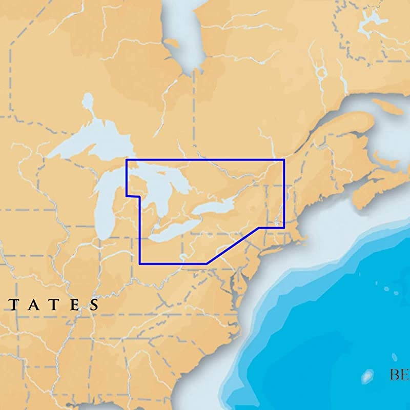
Platinum+ SD 901 East Great Lakes Nautical Chart on SD/Micro-SD Card - MSD/901P+
CTNR1273742 CTNR1273742Atlantic Tube & Steel
2027-06-23
/itm/platinum-sd-901-east-great-lakes-nautical-chart-on-sdmicro-sd-card-msd901p-1273742
USD
558.44
$ 559 $ 570 2% Off
Item Added to Cart
customer
*Product availability is subject to suppliers inventory
SHIPPING ALL OVER UNITED STATES
100% MONEY BACK GUARANTEE
EASY 30 DAYSRETURNS & REFUNDS
24/7 CUSTOMER SUPPORT
TRUSTED AND SAFE WEBSITE
100% SECURE CHECKOUT
Platinum+ East great lakes on SD/micro-SD card, manufacturer's part number SD/901P+, covers lakes Huron, Erie, and Ontario. award-winning Platinum+ charts, the most advanced multi-dimensional marine charts available, offer navigators a selection of bonus information beyond the best available navigation charts such as panoramic pictures, 3D/2D views w/satellite imagery, complete Coast Pilot guide, poi, high-definition fishing detail, and more. has amassed the most comprehensive mapping database of its kind with more than 25, 000 charts and port plans. Platinum+ Plug-and-play cartography is an indispensable component of the industry's leading chartplotter manufacturers including hummiNBird, lowrance, North Star, raymarine and simrad.
Visit for complete compatibility and coverage information.
Features: paper chart appearance for the clearest charts and best detail full seamless presentation with IC (intelligent clarity) technology user-selectable safety depth contours navaids with explain navaid Description feature port services with telephone Numbers (where available) including fuel, transient berths, repairs, and more tides & currents high-resolution satellite photo overlay 3-dimensional view panoramic port pictures Coastal points-of-interest high-definition fishing detail for us waters.