Trusted shipping
Easy returns
Secure shopping
- Clothing, Shoes, Jewelry & Watches
- Home, Garden, Outdoor & Pets
- Electronics
- Audio, Video & Portable Devices
- Cables
- Adapters & Gender Changers
- Headsets, Speakers & Soundcards
- Power Protection
- 3D Printing
- Video Cards & Video Devices
- Tools & Components
- Sound Cards
- Alternative Energy
- Barebone / Mini Computers
- SSDs
- Accessories
- Mobile Accessories
- Storage Devices
- Personal Care
- Healthcare
- Home Theatre Systems
- Laptops, Computers & Office
- Speakers & Audio Systems
- Tech Services & Support
- Projectors, TVs & Home Theater
- Wi-Fi & Networking
- Cell Phones
- Electronics Deals
- Headphones
- Tablets & E-Readers
- Digital Cameras
- Home Phones
- Tech Accessories
- Electronics Sanitizing & Cleaning Supplies
- Smart Home
- Batteries, Power Banks & Chargers
- Wearable Technology
- GPS & Navigation
- Movies, Music, Books & Games
- Luggage
- Bible Covers
- Briefcases
- Camo
- Coolers
- Toiletry Bags
- Tote Bags
- Backpacks
- Carry-on Luggage
- Checked Luggage
- Lunch Bags
- Travel Accessories
- Luggage Deals
- Laptop Bags & Briefcases
- Kids' Luggage
- Duffels & Gym Bags
- Suitcases
- RFID Blocking Luggage & Travel Accessories
- Luggage Sets
- Mens' Luggage
- Handbags
- Accessories
- Outdoor
- Beauty Luggage
- Travel Totes
- Garment Bags
- Weekenders
- Messenger Bags
- Beauty & Health
- Category List
- Clothing, Shoes, Jewelry & Watches
- Home, Garden, Outdoor & Pets
- Electronics
- Audio, Video & Portable Devices
- Cables
- Adapters & Gender Changers
- Headsets, Speakers & Soundcards
- Power Protection
- 3D Printing
- Video Cards & Video Devices
- Tools & Components
- Sound Cards
- Alternative Energy
- Barebone / Mini Computers
- SSDs
- Accessories
- Mobile Accessories
- Storage Devices
- Personal Care
- Healthcare
- Home Theatre Systems
- Laptops, Computers & Office
- Speakers & Audio Systems
- Tech Services & Support
- Projectors, TVs & Home Theater
- Wi-Fi & Networking
- Cell Phones
- Electronics Deals
- Headphones
- Tablets & E-Readers
- Digital Cameras
- Home Phones
- Tech Accessories
- Electronics Sanitizing & Cleaning Supplies
- Smart Home
- Batteries, Power Banks & Chargers
- Wearable Technology
- GPS & Navigation
- Movies, Music, Books & Games
- Luggage
- Bible Covers
- Briefcases
- Camo
- Coolers
- Toiletry Bags
- Tote Bags
- Backpacks
- Carry-on Luggage
- Checked Luggage
- Lunch Bags
- Travel Accessories
- Luggage Deals
- Laptop Bags & Briefcases
- Kids' Luggage
- Duffels & Gym Bags
- Suitcases
- RFID Blocking Luggage & Travel Accessories
- Luggage Sets
- Mens' Luggage
- Handbags
- Accessories
- Outdoor
- Beauty Luggage
- Travel Totes
- Garment Bags
- Weekenders
- Messenger Bags
- Beauty & Health
- Baby & Toys
- Sports & Outdoors
- School & Office Supplies
- Breakroom & Janitorial Supplies
- Diaries
- Utility & Stationary
- Pens & Pencils
- Teacher Supplies & Classroom Decorations
- Paper
- Markers
- Binders
- School Supplies
- Packing & Mailing Supplies
- Tape, Adhesives & Fasteners
- Boards & Easels
- Crayons
- Desk Organization
- Pencils
- Filing & Organizers
- Journals
- Pens
- Labels & Label Makers
- Tools & Equipment
- Calendars
- Sticky Notes
- Notebooks
- Erasers & Correction Tape
- Pencil Cases
- Planners
- Retail Store Supplies
- Highlighters
- Locker Accessories
- Cute School Supplies
- School & Office Accessories
- Food & Grocery
- Shops All
- Unique-Bargains
- Cool cold
- Wesdar
- i-Star
- CoCoCo
- Targus
- Cooling Device Accessories
- Xtrike Me
- Tech/Gaming
- Gift Cards
- Women's Accessories
- Flash
- Men's Clothing
- Gift Ideas
- Brand Experiences
- Sale on Select School & Art Supplies
- Jewelry
- Featured Brands
- Nursing Items
- Storage
- Men's Shoes
- College
- School & Office Supplies
- Bullseye's Playground
- PRIDE
- Women's and Men's Shoes & Accessories
- Holiday Trees, Lights & More Sale
- Women's Dresses
- Gingerbread
- Caregiver Essentials
- Baby Bath
- select School Supplies
- Doorbusters
- Bedding & Bath
- Women's Sandals
- Sandals for the Family
- Men's Accessories
- Shops All
- One-day Easter sale
- select Health Items
- Friendsgiving
- Women's Tops, Shorts & Shoes
- Made By Design Organization
- Baby Mealtime
- For New & Expecting Parents
- Crayola Kids' Daily Deal
- Spritz Party Supplies
- Wellness Icon Glossary
- Our Generation Dolls & Accessories Kids' Daily Deal
- select Home items
- Mas Que
- Baby Apparel
- Children's Board Books Kids' Daily Deal
- Select Office Furniture
- Most-added Wedding Registry Items
Buy Rand McNally U.S. Physical/Political Map Dry Erase Single Roller Mounted 50 x 32 RM528012762 in United States - Cartnear.com
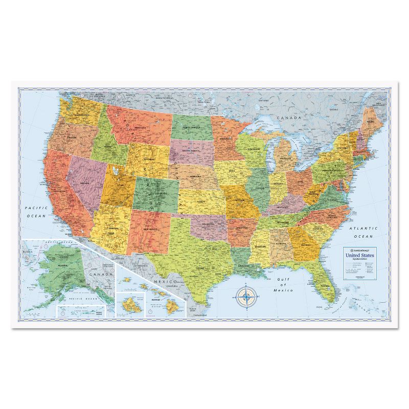
Rand McNally U.S. Physical/Political Map Dry Erase Single Roller Mounted 50 x 32 RM528012762
CTNR713251 070609012766 CTNR713251Rand McNally
2027-02-26
/itm/rand-mcnally-us-physicalpolitical-map-dry-erase-single-roller-mounted-50-x-32-rm528012762-713251
USD
38.5
$ 38 $ 39 2% Off
Item Added to Cart
customer
*Product availability is subject to suppliers inventory
SHIPPING ALL OVER UNITED STATES
100% MONEY BACK GUARANTEE
EASY 30 DAYSRETURNS & REFUNDS
24/7 CUSTOMER SUPPORT
TRUSTED AND SAFE WEBSITE
100% SECURE CHECKOUT
Dimensions (Overall): 33.99 inches (L), 1.74 inches (H) x 1.74 inches (W)
Weight: .0 pounds
Assembly Details: Adult Assembly Required, Tools Not Provided
Material: Paper
Battery: No Battery Used
Warranty: No Applicable Warranty. To obtain a copy of the manufacturer's or supplier's warranty for this item prior to purchasing the item,
• Sold as 1 Each.
• Bold colors and precise detail.
• An invaluable reference tool for home, office or classroom.
• Color-matching relief: trace mountain ranges easily while still locating city and state names quickly.
• Clearly labeled state capitals, national parks, time zones and major highways.
With a combination of bold colors and precise detail, signature laminated wall maps are an invaluable reference tool for home, office or classroom. Color-matching relief allows you to trace mountain ranges easily while still locating city and state names quickly. Clearly labeled state capitals, national parks, time zones and major highways. Map Type: Political/Physical; Map Region: U.S.; Style: Laminated; Surface: Dry Erase. Bold colors and precise detail. An invaluable reference tool for home, office or classroom. Color-matching relief: trace mountain ranges easily while still locating city and state names quickly. Clearly labeled state capitals, national parks, time zones and major highways. Sold as 1 Each.

