Trusted shipping
Easy returns
Secure shopping
Buy LakeMaster Plus MidSouth States Edition Digital GPS Lake and Aerial Maps Micro SD Card Version 3 Black in United States - Cartnear.com
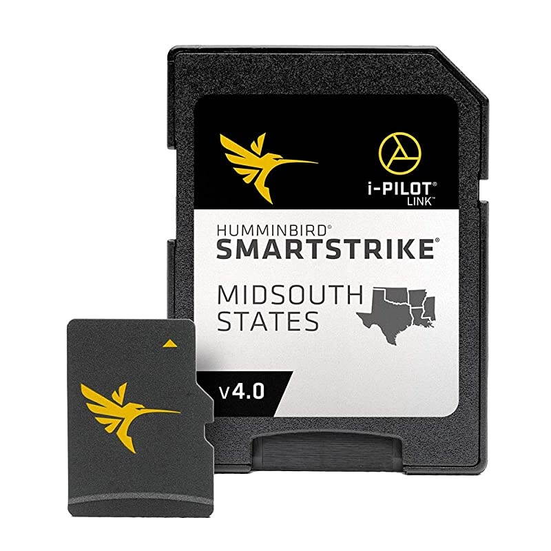
LakeMaster Plus MidSouth States Edition Digital GPS Lake and Aerial Maps Micro SD Card Version 3 Black
CTNR1188239 CTNR1188239VANGUARD
2027-03-15
/itm/lakemaster-plus-midsouth-states-edition-digital-gps-lake-and-aerial-maps-micro-sd-card-version-3-black-1188239
USD
148.39
$ 148 $ 151 2% Off
Item Added to Cart
customer
*Product availability is subject to suppliers inventory
SHIPPING ALL OVER UNITED STATES
100% MONEY BACK GUARANTEE
EASY 30 DAYSRETURNS & REFUNDS
24/7 CUSTOMER SUPPORT
TRUSTED AND SAFE WEBSITE
100% SECURE CHECKOUT
Size: LakeMaster PlusGet an added angling advantage with LakeMaster Plus mapping, which adds high-quality aerial photography to its unrivaled accuracy and detail, easy-to-read contours, highlighted depth ranges, and scrollable lake lists. LakeMaster digital maps provide the most detailed, high-definition collection of freshwater mapping in the United States, with unmatched depth contours between 1-3 feet (in high definition) or 3-5 feet (standard definition). This LakeMaster Plus Mid-South States Edition, Version 3 boasts more than 270 high-definition lakes and more than 385 total lakes from TX, OK, AR, LA, and MS, adding over 65 new lakes since the prior version. New high-definition lake map data includes Brady Branch Reservoir, Caddo, DeQueen (AR), Eufaula (OK), Grand Lake of the Cherokees, Livingston, Nacodgoches, Norfork, Robert S Kerr, Skiatook, Tawakoni, and more. LakeMaster Plus enables you to view an aerial image overlay on high-definition waters to see the entry and exits of creek channels, to see how far a reef or weed line extends, and to pick out shallow-water rock piles, steep drop-offs, and other features. Easy-to-see shading highlights shallow-water areas within an adjustable range up to 30 feet, and depth contours and shorelines can be synchronized with the actual water levels of lakes, reservoirs, and rivers.
LakeMaster digital maps can be used with Minn Kota i-Pilot Link (sold separately), allowing you to follow a selected depth contour line to deliver precise, automatic boat control. Collected by 's own team of GIS analyst cartographers, LakeMaster high-definition maps are created from on-the-water surveys using hundreds of thousands of depth soundings, plus state-of-the-art GPS and sonar technologies. LakeMaster Plus digital maps come on a Micro SD card (with included SD card adapter) that's compatible with all GPS-equipped HELIX, SOLIX, ONIX, and ION Series models and select 600-1100 Series models. Strictly intended for use in your GPS unit, LakeMaster mapping cards are not PC compatible and map files could be corrupted if accessed on a computer.
LakeMaster digital maps can be used with Minn Kota i-Pilot Link (sold separately), allowing you to follow a selected depth contour line to deliver precise, automatic boat control. Collected by 's own team of GIS analyst cartographers, LakeMaster high-definition maps are created from on-the-water surveys using hundreds of thousands of depth soundings, plus state-of-the-art GPS and sonar technologies. LakeMaster Plus digital maps come on a Micro SD card (with included SD card adapter) that's compatible with all GPS-equipped HELIX, SOLIX, ONIX, and ION Series models and select 600-1100 Series models. Strictly intended for use in your GPS unit, LakeMaster mapping cards are not PC compatible and map files could be corrupted if accessed on a computer.

![Micro USB Cable 90 Degree Right Angle [3 Pack / 10FT] Fast Charging Cable Quick Charger, High Speed Android Charging Cords for Galaxy S7 S6 J8 J7 Note 5,Kindle,LG,PS4,Camera (Red)](https://cdn.cartnear.com/7b0cac1f3704a3496a93adab105d9aed.jpg)